![]() |
|
Home | Forum | Online Store | Information | LJ Webcam | Gallery | Register | FAQ | Community | Calendar | Today's Posts | Search |
![]() |
|
Thread Tools | Display Modes |
|
![]() |
#1 |
Senior Member
Join Date: May 2006
Posts: 698
|
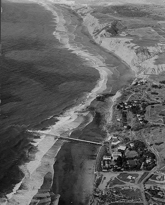
This 1952 photo shows Scripps canyon north of the pier, the other canyon (La Jolla) starts just south of the kayak launch, if you paddle due west from the launch you will cross it. They both connect out past the reserve line.
![]() |
![]() |
![]() |
![]() |
#2 |
Senior Member
Join Date: Jul 2007
Location: San Pedro
Posts: 999
|
wow would been nice to snatch up a few acres back in 1952
![]() |
![]() |
![]() |
![]() |
#3 |
Member
Join Date: Jan 2007
Location: Scripps Ranch
Posts: 82
|
The link below has fly-by videos of the La Jolla Canyon. These are large mpg files.
http://videos.windizzi.com/info?src=...60&duration=27 |
![]() |
![]() |
![]() |
#4 |
Senior Member
Join Date: Nov 2007
Location: San Diego
Posts: 279
|
I like this one as it shows the boundaries as well as the canyons.
La Jolla Map.jpg http://www.lajollaguide.com/ljsa/ima...ed1080x589.jpg
__________________
Don't try to confuse me with facts! I hereby reject your reality and submit my own. |
![]() |
![]() |
![]() |
#5 |
Member
Join Date: Jul 2008
Location: Encinitas
Posts: 600
|
beware of the HUGE leopard shark though....
|
![]() |
![]() |
![]() |
|
|